 In a recent post I discussed my 4th-great-grandfather James Benton McMurry’s travels from southern Kentucky to central Indiana in 1830. That got me to thinking, what were the roads he traveled along like? What routes did these roads follow? What sights and landmarks would James have encountered on the road? How long would the trip have taken?
Thanks to a pair of travel maps from 1829 and 1831, I know roughly where the roads of 1830 Kentucky and Indiana were located (these maps show the towns that are connected by roads, but the roads as illustrated therein are, to a large degree, schematic). Determination of the precise routes that these roads took will require a bit of what I call “armchair landscape archaeology.”
Landscape archaeology is the study of how humans have modified their physical environment, whether directly (e.g., building a dam or diverting a stream) or indirectly (e.g., through farming). Roads and highways, especially long-used ones, can leave enduring impressions on the landscape. The clues left by an old road, if read correctly, can aid in tracing the road’s long-abandoned route. Unlike prehistoric archaeological pursuits, the study of early 19th century transportation routes concerns structures that are relatively recent. It can therefore be considered a type of historical archaeology, because there may be written records and/or oral histories that can aid in understanding and contextualizing the subject of the investigation.
Here’s the Indiana portion of Tanner’s 1829 traveller’s map (see my previous post for additional views of this and the 1831 map):
I’m working from the assumption that James would have taken the most direct available route from his home in northern Allen County, Kentucky, to Crawfordsville, Indiana, where he purchased land for his future home near Roachdale, Indiana. The most direct route according to the 1829 Tanner map is the following:
- From his home in Bays Fork, KY, to Scottsville
- Scottsville to Glasgow
- Glasgow to Munfordsville
- Munfordsville to Elizabethtown
- Elizabethtown to Shepherdsville
- Shepherdsville to Louisville
- Louisville, KY to New Albany, IN, and the start of the Buffalo Trace
- Buffalo Trace to Paoli
- Paoli to Bedford
- Bedford to Bloomington
- Bloomington to Martinsville
- Martinsville to Indianapolis
- Indianapolis to Crawfordsville.
I mapped plotted all of these towns on Google Earth as a starting point.

I then went in and started to roughly identify what I thought were the oldest routes between each of the two towns identified by the 1829 map. In many cases these routes were still roads (albeit much more modern roads), but in some cases, the roads no longer existed. At this stage of the process, road names often prove themselves helpful. The original, single route to a neighboring town would often be (and frequently still is) called by the name of the town it led to (so the Scottsville–Glasgow road was called “Glasgow Road” on the Scottsville end, and “Scottsville Road” on the Glasgow end). Older roads will sometimes have “Old” or “Trail” in their modern names.
Once I “roughed in” the route I thought was most likely to represent the oldest road through the area, I went in at a much larger scale and began to reconstruct what I thought was the original route of these roads (which often had to change as newer roads, highways, railroads, and bridges were built near or through them, or as cities expanded and/or the land was put to other uses). The oldest roads tend to follow the topography and were built on the existing land surface without the use of cut, fills, or grades. As such, older roads weren’t linear where the landscape would not allow it. Compare Old Glasgow Road (below, highlighted in red) with New Glasgow Road as they traverse a series of low, rolling hills:

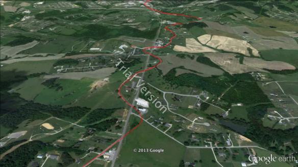
Sometimes the older route has been abandoned, torn up, or farmed over. Because a road, even an older road that is just built at ground level, has lasting impacts on the surrounding soil (e.g., compaction, drainage patterns, composition, erosion) and vegetation (e.g., distribution, differences in concentration), the routes of roads can still be traced long after the roads themselves have vanished (see below for an example):
 |
 |
Once I worked out what I thought were the oldest routes all along the route, I considered the result a hypothesis in need of testing. A first test is to see whether the routes I marked each corresponded to a marked road on the oldest available road maps. I found the oldest detailed road maps that I could, and used them to create semi-transparent map overlays in Google Earth.
The Kentucky Transportation Cabinet offers a series of county and state road maps from 1937 and 1939 on their historical maps page. I’m still looking for comparable maps of Indiana roads (the older roadmaps I’ve found—like this one from 1925—are state-wide, and thus too small-scale for verifying the details of local roads). The route I had mapped out corresponded very closely to roads that existed in 1937; in many cases, to roads that were even then considered byways or backroads. Even in 1937, modern, straight-as-an-arrow, high-speed roads had already started to take over the through traffic from the older roads that were designed and built perhaps a century before the first automobiles ever drove over them. As the roads I mapped out were already byways by 1937, I feel confident that these roads were at least several decades old by 1937.
I’d ideally like to find some mid-1800s maps of the relevant areas that accurately depict roads and highways, but I’m not optimistic that I’ll find any. It seems that accurate, large-scale roadmaps weren’t made until the early 1900s; earlier maps were too schematic and/or small-scale to help with this exercise.
There were a few areas in which I had made incorrect guesses as to the original route of the road (primarily around Barren River Lake, which has only existed since 1964, and the specifics of the route within cities). In these cases, I modified the hypothetical route to comply with routes that were available in 1937 (and presumably earlier).
Another test was to view the elevation profile (below) for the proposed route and use it to double check all portions of the route that had unusually sharp elevation changes. None of these turned out to be problematic.

I can’t think of any other tests I can do at the moment, at least not with information at hand, so I’ll leave this for further testing when I have more data against which to test it (e.g., older maps, gazetteers, locations and ages of old structures). In the meantime, I’d like to turn to a consideration of the road and the trip.

Based on the route I’ve identified, the road from Bays Fork, KY, to Crawfordsville, IN, was 322 miles long. The starting and ending altitude were similar: 640 feet above sea level (ASL) in Bays Fork, and 780 feet ASL in Crawfordsville. Between these two endpoints, the road passed over easy landscapes—gently rolling hills and flat plains. Because there were many small hills, the total elevation gain was 8,990 feet and the total elevation loss was -8,851 feet. The highest point of his journey was only 977 feet ASL (very near where he settled in Indiana), and the lowest point was 400 feet ASL in the Ohio River Valley near Louisville, KY.
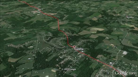
I’ve outlined the entire route in Google Earth, and if you’d like to see it in more detail, just download this file and open it with Google Earth. You can then do anything you like with it, including taking a tour along the route at any speed, angle, and elevation you prefer. Here’s just a snippet of what a portion of the route looks like from a 1,500 foot flyover (note that I’ve exaggerated the topography by a factor of 3 to make it easier to see):
And here’s what the entire route looks like from a 3,000 foot flyover:
The time it would have taken to traverse the 322 miles depends on the mode of transport, from 4.6 days in a stagecoach or up to 32 days with a wagon pulled by oxen:
| Mode | Average Speed | Daily distance | Journey Time |
|---|---|---|---|
| On foot | 2–3 mph | 30 miles | 10.7 days |
| Ox-drawn wagon | 1–2 mph | 10–12 miles | 27–32 days |
| Horse-drawn wagon | 2–3 mph | 15–25 miles | 12.9–21 days |
| Horseback | 3–4 mph | 40 miles | 8.1 days |
| Stagecoach | 5 mph | 60–70 miles | 4.6–5.4 days |
| Carriage | 5–8 mph | 25 miles | 12.9 days |
| Buggy | 10 mph | 25 miles | 12.9 days |
Would it be possible to travel along this route today? For the majority of the route, yes (although both the scenery and the road itself would look markedly different than they did to James 183 years ago). Parts of his route are no longer passable—the damming of Barren River to form Barren River Lake in 1964 put portions of the road underwater; the old bridges and/or ferries are long since gone; some old diagonal roads through cities no longer exist; portions run through the Fort Knox military base; and several portions cut across what is now private land. But most of the route is still passable, even if only in short segments.
I think it would be fun to travel over some of the more rural portions of the road on a mountain bike or other, similar, suitably low speed mode of transport. Someday I hope to have the time to do just that.
What fun! I enjoyed this very much!
Thanks, Anne! I’m so glad to hear you liked this post, and I really appreciate you letting me know—I really enjoyed writing it!
This was very interesting. Takes you right back in time.
Thanks, Ma!